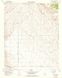
1966 Map of La Panza NE
USGS Topo · Published 1976About this map
The San Andreas Rift Zone dominates the northeast landscape of this 1966 survey, cutting a distinct geological path between the Temblor Range and the vast, arid expanse of the Carrizo Plain. This segment of the fault line reveals a network of canyons and seasonal drainages, where water remains a critical and scarce resource. Vital water sources such as Pinole Spring, Jenks Spring, and Mustang Spring are mapped alongside remote ranching infrastructure. Human presence is sparse, characterized by Pinole Ranch and functional landmarks like the Carrizo Plain Substation and scattered Storage Bins. The transport network consists primarily of unpaved tracks and graded routes, including Bitterwater Road and the San Juan Grade, which facilitate movement across this tectonic boundary during the mid-1960s.
Find a feature on this map
22 named features on this map. Tap any name to fly to it.
Don’t see what you’re looking for? This feature index may not catch every label — zoom into the map to look around manually.
Map Details
Editions of this 1966 La Panza NE Map
2 editions found
Other maps of this area

1912 · McKittrick
USGS Topo · 1:125,000

1914 · Lost Hills
USGS Topo · 1:125,000

1914 · Cholame
USGS Topo · 1:125,000

1915 · Cholame
USGS Topo · 1:125,000

1917 · Cholame
USGS Topo · 1:125,000

1932 · La Panza
USGS Topo · 1:48,000

1935 · La Panza
USGS Topo · 1:62,500

1936 · La Panza
USGS Topo · 1:62,500

1943 · Packwood
USGS Topo · 1:31,680

1943 · Grant Lake
USGS Topo · 1:31,680