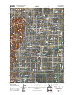
2011 Map of La Pine
USGS Topo · Published 2011About this map
La Pine and its surrounding high-desert landscape are defined by the winding course of the Little Deschutes River as it moves through marshy lowlands toward its confluence near Pringle Falls. The early 21st-century topography shows a grid of rural residential development expanding east of the river, while the west remains largely characterized by volcanic features and open meadows. Prominent landmarks such as Pringle Butte, Cruiser Butte, and Wampus Butte rise above the flatlands, providing clear geographic anchors. For those looking into local history, the map identifies the Masten Cemetery and several named agricultural holdings, including Carey Stearns Ranch, Gilbertson Ranch, and Springer Ranch. The town center is marked by the La Pine Post Office and an established street network including Burgess Rd and 6th St, illustrating the community's role as a regional hub between the river and the vast timberlands to the west.
Find a feature on this map
58 named features on this map. Tap any name to fly to it.
Don’t see what you’re looking for? This feature index may not catch every label — zoom into the map to look around manually.
Map Details
Editions of this 2011 La Pine Map
This is the sole edition of this map. No revisions or reprints were ever made.
Other maps of this area

1930 · Maiden Peak
USGS Topo · 1:125,000

1931 · Newberry Crater
USGS Topo · 1:125,000

1934 · Maiden Peak
USGS Topo · 1:125,000

1935 · Newberry Crater
USGS Topo · 1:125,000

1955 · Crescent
USGS Topo · 1:250,000

1957 · Crescent
USGS Topo · 1:250,000

1958 · Crescent
USGS Topo · 1:250,000

1963 · Round Mountain
USGS Topo · 1:24,000
1963 · Anns Butte
USGS Topo · 1:24,000

1963 · La Pine
USGS Topo · 1:24,000