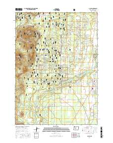
2017 Map of La Pine
USGS Topo · Published 2017About this map
Deschutes National Forest dominates this Central Oregon landscape, where the Deschutes River and Little Deschutes River converge amidst a volcanic topography of cinder cones and meadows. The settlement of La Pine serves as the primary hub along the eastern edge, showing a distinct grid of residential roads like Paulina Ave and Davis Ave that contrast with the winding forest service routes to the west. Evidence of early land use and local heritage is anchored by the Masten Cem, located near the southern reaches of the quadrangle. The terrain is defined by prominent elevations including Pringle Butte, Cruiser Butte, and Wampus Butte, which overlook expansive openings like Dorrance Meadow. This map documents the intersection of public forest management and a growing residential community in a high-desert environment defined by its watercourses and prehistoric geology.
Find a feature on this map
59 named features on this map. Tap any name to fly to it.
Don’t see what you’re looking for? This feature index may not catch every label — zoom into the map to look around manually.
Map Details
Editions of this 2017 La Pine Map
This is the sole edition of this map. No revisions or reprints were ever made.
Other maps of this area

1930 · Maiden Peak
USGS Topo · 1:125,000

1931 · Newberry Crater
USGS Topo · 1:125,000

1934 · Maiden Peak
USGS Topo · 1:125,000

1935 · Newberry Crater
USGS Topo · 1:125,000

1955 · Crescent
USGS Topo · 1:250,000

1957 · Crescent
USGS Topo · 1:250,000

1958 · Crescent
USGS Topo · 1:250,000

1963 · Round Mountain
USGS Topo · 1:24,000
1963 · Anns Butte
USGS Topo · 1:24,000

1963 · La Pine
USGS Topo · 1:24,000