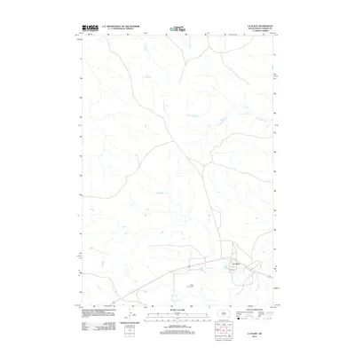
2012 Map of La Plant
USGS Topo · Published 2012About this map
La Plant serves as the primary focal point of this Dewey County landscape, situated where the road network converges in the southern portion of the quadrangle. The terrain is defined by a dendritic drainage system where Johnson Cr and Blue Beaver Cr flow southward, eventually feeding into the larger drainage area of Virgin Cr. A notable point of interest for genealogists and local historians is the Rushs Enemy Cem, located southwest of the main settlement. The map illustrates a predominantly rural and open landscape, typical of the Missouri River region's upper reaches, characterized by numerous smaller tributaries like Left Hand Bear Cr that carve through the prairie. This documentation provides a clear view of the sparse settlement patterns and the vital relationship between the small community and its surrounding water sources in the early 21st century.
Find a feature on this map
6 named features on this map. Tap any name to fly to it.
Don’t see what you’re looking for? This feature index may not catch every label — zoom into the map to look around manually.
Map Details
Editions of this 2012 La Plant Map
This is the sole edition of this map. No revisions or reprints were ever made.
Other maps of this area

1951 · Virginia
USGS Topo · 1:24,000

1951 · Ridgeview NE
USGS Topo · 1:24,000

1951 · La Plant
USGS Topo · 1:24,000

1951 · Promise
USGS Topo · 1:24,000

1952 · Trail City SW
USGS Topo · 1:24,000

1952 · Glencross SE
USGS Topo · 1:24,000

1953 · McIntosh
USGS Topo · 1:250,000

1958 · McIntosh
USGS Topo · 1:250,000
1981 · Stove Creek
USGS Topo · 1:24,000
1981 · La Plant SW
USGS Topo · 1:24,000