
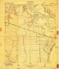
1916 Map of La Porte
USGS Topo · Published 1916About this map
San Jacinto Battlefield overlooks the confluence of the San Jacinto River and Buffalo Bayou, anchoring a landscape defined by the growing maritime commerce of the early twentieth century. This survey documents the Houston-Galveston Ship Channel as it bypasses Peggy Lake and Scott Bay, cutting through a complex of low-lying islands like Busch Island and Spilman Island. The shoreline of Galveston Bay is dotted with coastal developments such as Sylvan Beach, Sylvain, and Oaks, reflecting the area's emerging role as a recreational and residential destination.
Find a feature on this map
42 named features on this map. Tap any name to fly to it.
Don’t see what you’re looking for? This feature index may not catch every label — zoom into the map to look around manually.
Map Details
Editions of this 1916 La Porte Map
2 editions found
Other maps of this area

1915 · Deepwater
USGS Topo · 1:24,000

1916 · Genoa
USGS Topo · 1:24,000

1916 · Burnett Bay
USGS Topo · 1:24,000

1916 · Morgan Point
USGS Topo · 1:24,000

1916 · Seabrook
USGS Topo · 1:24,000

1916 · Fauna
USGS Topo · 1:24,000

1916 · Cedar Bayou
USGS Topo · 1:24,000

1919 · Morgan Point
USGS Topo · 1:31,680

1919 · Deepwater
USGS Topo · 1:31,680

1919 · Cedar Bayou
USGS Topo · 1:31,680