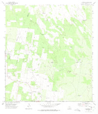
1972 Map of La Reforma
USGS Topo · Published 1975About this map
Windmills and oil exploration define this arid landscape along the Starr Co Hidalgo Co boundary during the early 1970s. The region is marked by isolated settlements like La Reforma and Cipres, where life revolved around ranching and the emerging energy industry. The presence of numerous named water sources, such as Hargrove Windmill and Noche Buena Windmill, underscores the vital importance of groundwater in this brush-covered terrain.
Find a feature on this map
33 named features on this map. Tap any name to fly to it.
Don’t see what you’re looking for? This feature index may not catch every label — zoom into the map to look around manually.
Map Details
Editions of this 1972 La Reforma Map
2 editions found
Other maps of this area

1939 · Linn
USGS Topo · 1:62,500

1939 · La Reforma
USGS Topo · 1:62,500

1939 · Encantada
USGS Topo · 1:62,500

1949 · Mc Allen
USGS Topo · 1:250,000

1954 · McAllen
USGS Topo · 1:250,000

1957 · Mc Allen
USGS Topo · 1:250,000

1962 · McAllen
USGS Topo · 1:250,000

1963 · Linn NW
USGS Topo · 1:24,000
1963 · Linn Siding
USGS Topo · 1:24,000
1963 · Hartland
USGS Topo · 1:24,000