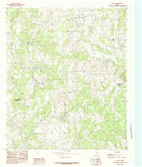
1984 Map of La Rue
USGS Topo · Published 1984About this map
The community of LaRue sits at the intersection of local history and hydrologic importance along the Henderson and Anderson county line. This 1984 provisional survey, based on field checks from 1978, illustrates a landscape heavily defined by water management and private lake systems. Notable water bodies such as Rainbo Lake, Alder Lake, and Fincastle Lake punctuate the terrain, indicating a period of recreational or agricultural development. The settlement of Fincastle serves as a secondary focal point near the central lakes, while a small Cem nearby provides a potential touchpoint for family historians. The drainage pattern is complex, with Caddo Creek and its expansive Caddo Creek Lake dominating the northeast, while Brushy Creek and Indian Creek weave through the southern timberlands. The presence of Pharris Lakes and Mawsy Lake further suggests a region characterized by small-scale impoundments typical of this era in East Texas.
Find a feature on this map
23 named features on this map. Tap any name to fly to it.
Don’t see what you’re looking for? This feature index may not catch every label — zoom into the map to look around manually.
Map Details
Editions of this 1984 La Rue Map
This is the sole edition of this map. No revisions or reprints were ever made.
Other maps of this area

1949 · Palestine
USGS Topo · 1:62,500

1949 · Frankston
USGS Topo · 1:62,500

1949 · Athens
USGS Topo · 1:62,500

1949 · Tennessee Colony
USGS Topo · 1:62,500

1950 · Athens
USGS Topo · 1:62,500

1950 · Palestine
USGS Topo · 1:62,500

1950 · Frankston
USGS Topo · 1:62,500

1950 · Tennessee Colony
USGS Topo · 1:62,500

1953 · Palestine
USGS Topo · 1:250,000

1956 · Tyler
USGS Topo · 1:250,000