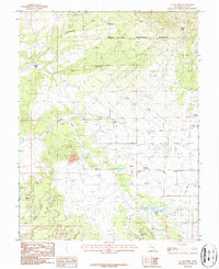
1987 Map of La Sal West
USGS Topo · Published 1987About this map
Manti-La Sal National Forest dominates the northern reaches of this high-desert landscape, where the transition from timbered slopes to arid drainages reveals a history of intense resource extraction. The area around the small settlement of La Sal is marked by a complex network of industrial infrastructure, particularly concentrated in the south near the Lisbon Mine and Alice Mine. This 1980s data highlights the significance of the region's mineral wealth, showing the Homestake Mine and the Hecla Shaft alongside multiple uranium and vanadium-bearing geological features. Local landmarks like Wilson Arch provide a striking contrast to the industrial footprint of the Open Pit Mine and scattered Oil Wells. The presence of a local Cem and a Trailer Park near the town center indicates a community built around the shifting needs of the mining and ranching industries that have long shaped San Juan County.
Find a feature on this map
26 named features on this map. Tap any name to fly to it.
Don’t see what you’re looking for? This feature index may not catch every label — zoom into the map to look around manually.
Map Details
Editions of this 1987 La Sal West Map
3 editions found
Other maps of this area

1885 · La Sal
USGS Topo · 1:250,000

1954 · Mt Peale 3 NW
USGS Topo · 1:24,000

1954 · Mt Peale 4 NW
USGS Topo · 1:24,000

1954 · Mt Peale 3 NE
USGS Topo · 1:24,000

1954 · Mt Peale 1 SW
USGS Topo · 1:24,000

1954 · Mt Peale 1 NW
USGS Topo · 1:24,000

1954 · Mt Peale 2 SW
USGS Topo · 1:24,000

1954 · Mt Peale 2 NW
USGS Topo · 1:24,000

1954 · Mt Peale 2 SE
USGS Topo · 1:24,000

1954 · Mt Peale 2 NE
USGS Topo · 1:24,000