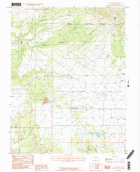
1987 Map of La Sal West
USGS Topo · Published 1987About this map
Mining operations and high-desert drainage patterns define this 1980s landscape in San Juan County. The settlement of La Sal sits at the eastern edge of the quadrangle, serving as a hub for the surrounding extractive industries. The southern portion of the map is particularly dense with mineral history, showing the Lisbon Mine, Alice Mine, and the Homestake Mine near a local substation. These industrial sites are interspersed with natural landmarks like the Wilson Arch and the deep cuts of Joe Wilson Canyon.
Find a feature on this map
24 named features on this map. Tap any name to fly to it.
Don’t see what you’re looking for? This feature index may not catch every label — zoom into the map to look around manually.
Map Details
Editions of this 1987 La Sal West Map
3 editions found
Other maps of this area

1885 · La Sal
USGS Topo · 1:250,000

1954 · Mt Peale 3 NW
USGS Topo · 1:24,000

1954 · Mt Peale 4 NW
USGS Topo · 1:24,000

1954 · Mt Peale 3 NE
USGS Topo · 1:24,000

1954 · Mt Peale 1 SW
USGS Topo · 1:24,000

1954 · Mt Peale 1 NW
USGS Topo · 1:24,000

1954 · Mt Peale 2 SW
USGS Topo · 1:24,000

1954 · Mt Peale 2 NW
USGS Topo · 1:24,000

1954 · Mt Peale 2 SE
USGS Topo · 1:24,000

1954 · Mt Peale 2 NE
USGS Topo · 1:24,000