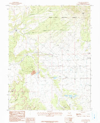
1987 Map of La Sal West
USGS Topo · Published 1987About this map
Mining operations and high-desert drainage patterns define this late-century landscape on the edge of the Manti-La Sal National Forest. The map documents a significant industrial footprint concentrated around La Sal, characterized by numerous uranium and vanadium prospects such as the Lisbon Mine, Homestake Mine, and Alice Mine. Vertical infrastructure is noted through the Hecla Shaft and Beaver Shaft, while an Oil Well and a large Substation further illustrate the area's role in resource extraction and power distribution. The rugged geography is carved by seasonal watercourses like Cottonwood Canyon and West Coyote Wash, providing a stark contrast to the human-made excavations. Natural landmarks, including the notable Wilson Arch in Wilson Canyon and the high elevations of Lackey Basin, serve as fixed points in a terrain constantly being reshaped by the search for mineral wealth.
Find a feature on this map
20 named features on this map. Tap any name to fly to it.
Don’t see what you’re looking for? This feature index may not catch every label — zoom into the map to look around manually.
Map Details
Editions of this 1987 La Sal West Map
3 editions found
Other maps of this area

1885 · La Sal
USGS Topo · 1:250,000

1954 · Mt Peale 3 NW
USGS Topo · 1:24,000

1954 · Mt Peale 4 NW
USGS Topo · 1:24,000

1954 · Mt Peale 3 NE
USGS Topo · 1:24,000

1954 · Mt Peale 1 SW
USGS Topo · 1:24,000

1954 · Mt Peale 1 NW
USGS Topo · 1:24,000

1954 · Mt Peale 2 SW
USGS Topo · 1:24,000

1954 · Mt Peale 2 NW
USGS Topo · 1:24,000

1954 · Mt Peale 2 SE
USGS Topo · 1:24,000

1954 · Mt Peale 2 NE
USGS Topo · 1:24,000