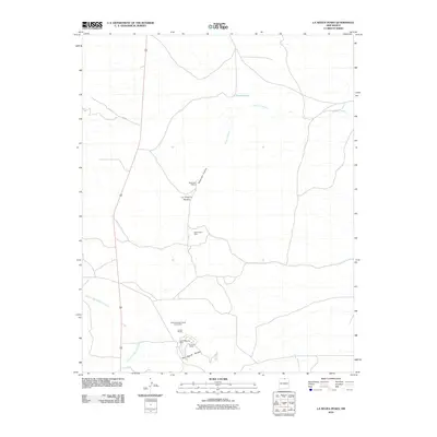
2010 Map of La Segita Peaks
USGS Topo · Published 2010About this map
Volcanic geology and industrial mineral extraction define this section of Rio Arriba County. The landscape is marked by prominent natural features such as the Wissmath Craters and the towering summits of La Segita Peaks. This 2010 survey highlights a significant hub of mining activity in the southern region, particularly surrounding the No Agua Peaks. Industrial operations including the Johns Manville Perlite Corporation, United Perlite, and the Johns-Manville Mine suggest the area's importance for perlite production during the early 21st century. Drainage patterns are dominated by the Arroyo Punche, which flows through the northern reaches near Punche Lake, and the winding Arroyo Aguaje de la Petaca to the southwest. Away from the concentrated mining sites, the terrain remains largely defined by open expanses and remote forest access via routes like F R 418.
Find a feature on this map
12 named features on this map. Tap any name to fly to it.
Don’t see what you’re looking for? This feature index may not catch every label — zoom into the map to look around manually.
Map Details
Editions of this 2010 La Segita Peaks Map
This is the sole edition of this map. No revisions or reprints were ever made.
Other maps of this area

1918 · Tusas
USGS Topo · 1:125,000

1954 · Raton
USGS Topo · 1:250,000

1954 · Aztec
USGS Topo · 1:250,000

1958 · Raton
USGS Topo · 1:250,000

1958 · Aztec
USGS Topo · 1:250,000

1962 · Aztec
USGS Topo · 1:250,000
1963 · Los Pinos
USGS Topo · 1:24,000

1963 · Pinabetoso Peaks
USGS Topo · 1:24,000

1963 · Tres Piedras NE
USGS Topo · 1:24,000

1963 · Cerro De La Olla
USGS Topo · 1:24,000