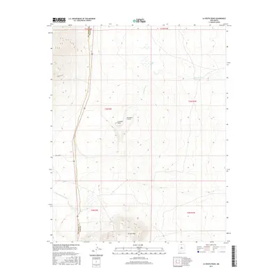
2017 Map of La Segita Peaks
USGS Topo · Published 2017About this map
La Segita Peaks and the volcanic formations of the Wissmath Craters dominate this northern New Mexico landscape along the boundary of Rio Arriba and Taos counties. This 2017 study illustrates a high-elevation environment where geologic features like the No Agua Peaks rise above the surrounding plateau. The drainage patterns are defined by seasonal watercourses such as Arroyo Punche, which feeds into Punche Lake, and the Arroyo Aguaje de la Petaca in the southwest.
Find a feature on this map
15 named features on this map. Tap any name to fly to it.
Don’t see what you’re looking for? This feature index may not catch every label — zoom into the map to look around manually.
Map Details
Editions of this 2017 La Segita Peaks Map
This is the sole edition of this map. No revisions or reprints were ever made.
Other maps of this area

1918 · Tusas
USGS Topo · 1:125,000

1954 · Raton
USGS Topo · 1:250,000

1954 · Aztec
USGS Topo · 1:250,000

1958 · Raton
USGS Topo · 1:250,000

1958 · Aztec
USGS Topo · 1:250,000

1962 · Aztec
USGS Topo · 1:250,000
1963 · Los Pinos
USGS Topo · 1:24,000

1963 · Pinabetoso Peaks
USGS Topo · 1:24,000

1963 · Tres Piedras NE
USGS Topo · 1:24,000

1963 · Cerro De La Olla
USGS Topo · 1:24,000