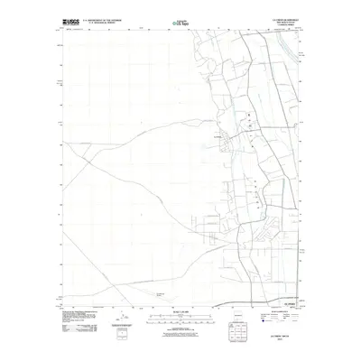
2010 Map of La Union
USGS Topo · Published 2010About this map
The fertile Mesilla Valley defines the character of this landscape at the edge of New Mexico and Texas, where a complex network of irrigation and drainage systems supports the agricultural land around La Union. The intricate placement of water features like La Union West Lateral, La Union East Lateral, and West Drain illustrates the sophisticated water management required in this arid river valley. These channels, along with others like Talbot Lateral and Deck Lateral, divide the land into a geometric grid of fields and farm roads. Toward the south, the terrain transitions as it approaches the Santa Teresa Airport, while the western portion of the map is dominated by the long, straight reaches of County Rd A089 and Santa Teresa International Blvd, connecting the valley to the higher desert plateaus beyond.
Find a feature on this map
38 named features on this map. Tap any name to fly to it.
Don’t see what you’re looking for? This feature index may not catch every label — zoom into the map to look around manually.
Map Details
Editions of this 2010 La Union Map
This is the sole edition of this map. No revisions or reprints were ever made.
Other maps of this area

1891 · Las Cruces
USGS Topo · 1:125,000

1893 · Las Cruces
USGS Topo · 1:125,000

1917 · Canutillo
USGS Topo · 1:62,500

1917 · Noria
USGS Topo · 1:62,500

1918 · Noria
USGS Topo · 1:62,500

1919 · Canutillo
USGS Topo · 1:62,500

1943 · La Mesa
USGS Topo · 1:62,500

1943 · Afton
USGS Topo · 1:62,500

1953 · El Paso
USGS Topo · 1:250,000
1955 · Smeltertown
USGS Topo · 1:24,000