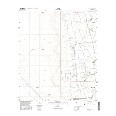
2017 Map of La Union
USGS Topo · Published 2017About this map
The Mesilla Valley defines the fertile character of this borderlands region, where the Rio Grande serves as a natural and political boundary between New Mexico and Texas. Agricultural irrigation remains central to the landscape, evidenced by a dense network of water control features including the La Union W Lateral, Talbot Lateral, and the West Drain. These channels support the rural community of La Union, which sits at the heart of the valley's drainage system. Along the eastern edge, the topography shifts toward the urban reach of Anthony and the northern outskirts of El Paso. Transportation and aviation hubs like the Dona Ana County Airport at Santa Teresa and the Cielo Dorado Estates Airport reflect the area's development as a modern crossroads. The map also traces numerous named local routes such as Mesa Visita Rd and Vinton Rd, providing a detailed look at the interface between established farmland and growing residential zones.
Find a feature on this map
81 named features on this map. Tap any name to fly to it.
Don’t see what you’re looking for? This feature index may not catch every label — zoom into the map to look around manually.
Map Details
Editions of this 2017 La Union Map
This is the sole edition of this map. No revisions or reprints were ever made.
Other maps of this area

1891 · Las Cruces
USGS Topo · 1:125,000

1893 · Las Cruces
USGS Topo · 1:125,000

1917 · Canutillo
USGS Topo · 1:62,500

1917 · Noria
USGS Topo · 1:62,500

1918 · Noria
USGS Topo · 1:62,500

1919 · Canutillo
USGS Topo · 1:62,500

1943 · La Mesa
USGS Topo · 1:62,500

1943 · Afton
USGS Topo · 1:62,500

1953 · El Paso
USGS Topo · 1:250,000
1955 · Smeltertown
USGS Topo · 1:24,000