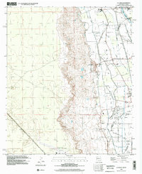
1996 Map of La Union
USGS Topo · Published 2002About this map
The Mesilla Valley defines the eastern half of this landscape, where a complex network of irrigation ditches and drains manages the flow of the Rio Grande. This agricultural system, featuring the Deck Lateral, La Union West Lateral, and Vinton Drain, supports the settlement of La Union and the expansive Refugio Colony Tract No 1. The map captures the meeting of desert and developed valley, with the western terrain rising toward the Mada area and the southern portion dominated by the Dona Ana County at Santa Teresa Airport and the community of Santa Teresa. Local institutional life is well-documented through the presence of the Gadsden High Sch, St Lukes Ch, and a local Cem, reflecting a established rural community structure at the turn of the 21st century.
Find a feature on this map
40 named features on this map. Tap any name to fly to it.
Don’t see what you’re looking for? This feature index may not catch every label — zoom into the map to look around manually.
Map Details
Editions of this 1996 La Union Map
This is the sole edition of this map. No revisions or reprints were ever made.
Other maps of this area

1891 · Las Cruces
USGS Topo · 1:125,000

1893 · Las Cruces
USGS Topo · 1:125,000

1917 · Canutillo
USGS Topo · 1:62,500

1917 · Noria
USGS Topo · 1:62,500

1918 · Noria
USGS Topo · 1:62,500

1919 · Canutillo
USGS Topo · 1:62,500

1943 · La Mesa
USGS Topo · 1:62,500

1943 · Afton
USGS Topo · 1:62,500

1953 · El Paso
USGS Topo · 1:250,000
1955 · Smeltertown
USGS Topo · 1:24,000