
1958 Map of La Vernia SW
USGS Topo · Published 1961About this map
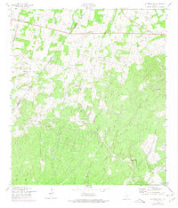
The Bexar Co Wilson Co boundary line bisects this landscape of south-central Texas, as it appeared in the late 1950s. The northern portion of the quadrangle is defined by agricultural activity and industrial development, most notably the Cooksey Oil Field and a prominent Pipeline corridor. Transport is dominated by the Southern Pacific rail line and a network of unimproved roads connecting small rural clusters like Lone Oak. In the south, the terrain becomes more pronounced as the drainage of Kicaster Creek and Dry Hollow carves through the earth, leading toward landmarks such as Rocky Point and Red Bluff. This survey captures the rural character of the area before modern expansion, preserving the locations of the La Vernia Cem and the small settlement of Grass Pond Colony near the southeastern edge.
Find a feature on this map
12 named features on this map. Tap any name to fly to it.
Don’t see what you’re looking for? This feature index may not catch every label — zoom into the map to look around manually.
Map Details
Editions of this 1958 La Vernia SW Map
2 editions found
Other maps of this area

1936 · Floresville
USGS Topo · 1:62,500

1953 · Elmendorf
USGS Topo · 1:24,000

1953 · Martinez
USGS Topo · 1:24,000

1954 · San Antonio
USGS Topo · 1:250,000

1957 · San Antonio
USGS Topo · 1:250,000

1957 · New Berlin
USGS Topo · 1:24,000

1958 · Saspamco
USGS Topo · 1:24,000
1958 · Saint Hedwig
USGS Topo · 1:24,000
1961 · Marcelinas Hills
USGS Topo · 1:24,000
1961 · Floresville
USGS Topo · 1:24,000