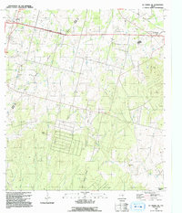
1992 Map of La Vernia SW
USGS Topo · Published 1992About this map
Cooksey Oil Field dominates the central landscape of this Wilson County region, illustrating the industrial footprint of petroleum extraction in South Texas during the late 20th century. The map captures the boundary between Bexar and Wilson Counties, showing a rural landscape in transition. Significant local activity is visible through the presence of a Landing Strip, a Gravel Pit, and various radio towers. Traditional settlement patterns remain centered around La Vernia and Lone Oak, with the Old Railroad Grade marking the path of former transportation routes. Watercourses like Kieaster Creek and Dry Hollow define the drainage patterns toward the southeast, while family and community history is anchored by the La Vernia Cem and the outlying Grass Pond Colony.
Find a feature on this map
18 named features on this map. Tap any name to fly to it.
Don’t see what you’re looking for? This feature index may not catch every label — zoom into the map to look around manually.
Map Details
Editions of this 1992 La Vernia SW Map
This is the sole edition of this map. No revisions or reprints were ever made.
Other maps of this area

1936 · Floresville
USGS Topo · 1:62,500

1953 · Elmendorf
USGS Topo · 1:24,000

1953 · Martinez
USGS Topo · 1:24,000

1954 · San Antonio
USGS Topo · 1:250,000

1957 · San Antonio
USGS Topo · 1:250,000

1957 · New Berlin
USGS Topo · 1:24,000

1958 · La Vernia SW
USGS Topo · 1:24,000

1958 · Saspamco
USGS Topo · 1:24,000
1958 · Saint Hedwig
USGS Topo · 1:24,000
1961 · Marcelinas Hills
USGS Topo · 1:24,000