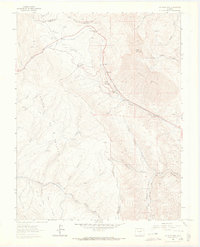
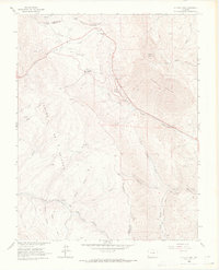
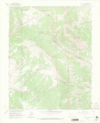
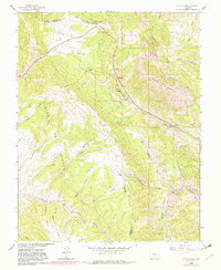
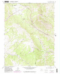
1963 Map of La Veta Pass
USGS Topo · Published 1966About this map
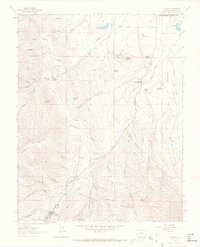
North La Veta Pass and the lower La Veta Pass anchor this high-altitude survey of the Sangre de Cristo Range on the Huerfano and Costilla County border. The landscape is defined by the legacy of mountain transit, where the Denver and Rio Grande Western railroad winds through the passes alongside the historic Wagon Toll Road. These corridors of movement served remote outposts like Muleshoe and Codo, while the Mallet Vega Camp sits deep within the western canyons. The topographic detail reveals a complex network of drainages including Missouri Creek and North Abeyta Creek, which carve through the elevations between Mount Mestas and Dump Mountain. This 1963 snapshot captures the infrastructure of the Southern Rockies just as modern highway improvements were beginning to reshape these traditional pass routes, yet it preserves the locations of early resource extraction like the Mine and Gravel Pit near Windy Point.
Find a feature on this map
39 named features on this map. Tap any name to fly to it.
Don’t see what you’re looking for? This feature index may not catch every label — zoom into the map to look around manually.
Map Details
Editions of this 1963 La Veta Pass Map
7 editions found

Other maps of this area

1889 · Huerfano Park
USGS Topo · 1:125,000

1892 · Huerfano Park
USGS Topo · 1:125,000

1954 · Trinidad
USGS Topo · 1:250,000

1955 · Trinidad
USGS Topo · 1:250,000

1958 · Trinidad
USGS Topo · 1:250,000

1959 · Trinidad
USGS Topo · 1:250,000
1963 · Mc Carty Park
USGS Topo · 1:24,000
1963 · La Veta Pass
USGS Topo · 1:24,000
1963 · La Veta
USGS Topo · 1:24,000
1963 · Cuchara
USGS Topo · 1:24,000