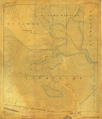
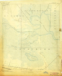
1892 Map of Lac Des Allemands
USGS Topo · Published 1898About this map
The expansive Lake Des Allemands and its surrounding wetlands dominate this late nineteenth-century landscape at the junction of four Louisiana parishes. The map reveals a complex hydrologic network of bayous including Bayou Boeuf, Bayou Heron, and Bayou Chactimaghan, which drain the low-lying Grand Prairie Des Allemands. Near the center of this marshy expanse, an Indian Mound stands as a notable cultural landmark. Human settlement and industry are concentrated at the edges of the swamp, particularly along the Bayou Lafourche corridor. Here, the Southern Pacific Railroad and the T. & P. R. R. provided vital transportation links for communities like Raceland Station and Vacherie. The contrast between the undeveloped marsh and the narrow strips of agricultural and rail-based settlement reflects the distinct environmental constraints of the region before modern drainage projects.
Find a feature on this map
21 named features on this map. Tap any name to fly to it.
Don’t see what you’re looking for? This feature index may not catch every label — zoom into the map to look around manually.
Map Details
Editions of this 1892 Lac Des Allemands Map
4 editions found

Other maps of this area

1891 · Hahnville
USGS Topo · 1:62,500

1892 · Lac Des Allemands
USGS Topo · 1:62,500

1892 · Mount Airy
USGS Topo · 1:62,500

1892 · Gibson
USGS Topo · 1:62,500

1892 · Bonnet Carre
USGS Topo · 1:62,500

1892 · Cut-Off
USGS Topo · 1:62,500

1892 · Houma
USGS Topo · 1:62,500

1892 · Donaldsonville
USGS Topo · 1:62,500

1892 · Thibodaux
USGS Topo · 1:62,500

1897 · Gibson
USGS Topo · 1:62,500