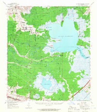
1962 Map of Lac Des Allemands
USGS Topo · Published 1966About this map
Lac Des Allemands dominates this landscape, its waters reaching into complex bays like Baie A Carlin and Baie Chevreuil. The surrounding lowlands of Rathborne Swamp reveal a transition from plantation-based agriculture to industrial extraction, with the Lucy Gas Field and Lac Des Allemands Gas Field interspersed among established estates. Historic holdings such as Southdown Plantation, Webre Steib Plantation, and Golden Star Plantation line the higher ground near Vacherie, while the southern reaches near Bayou-Boeuf and Rousseau show the influence of the Southern Pacific and Texas And Pacific railroads. The area's social fabric is anchored by local institutions like Lady of Mercy Ch and Choctaw Sch. Waterways including Bayou Chevreuil and the Dredge Canal illustrate the vital role of drainage and navigation in the development of Lafourche Parish.
Find a feature on this map
59 named features on this map. Tap any name to fly to it.
Don’t see what you’re looking for? This feature index may not catch every label — zoom into the map to look around manually.
Map Details
Editions of this 1962 Lac Des Allemands Map
2 editions found
Other maps of this area

1891 · Hahnville
USGS Topo · 1:62,500

1892 · Lac Des Allemands
USGS Topo · 1:62,500

1892 · Mount Airy
USGS Topo · 1:62,500

1892 · Gibson
USGS Topo · 1:62,500

1892 · Bonnet Carre
USGS Topo · 1:62,500

1892 · Cut-Off
USGS Topo · 1:62,500

1892 · Houma
USGS Topo · 1:62,500

1892 · Donaldsonville
USGS Topo · 1:62,500

1892 · Thibodaux
USGS Topo · 1:62,500

1897 · Gibson
USGS Topo · 1:62,500