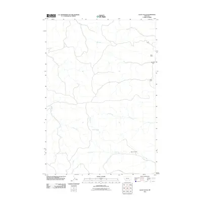
2011 Map of Lacey Gulch
USGS Topo · Published 2011About this map
Cox Ranch sits in the northeastern reaches of this landscape, marking a localized human footprint in a region dominated by drainage networks and intermittent water sources. The terrain is defined by a series of significant erosional features, including Lacey Gulch, Van Meter Gulch, and Bad Land Gulch, which channel seasonal runoff toward larger systems like Wrench Creek and P K Creek. These names reflect the historical ranching character and topography of Rosebud County, where land use is tied closely to the available water from the 08S42E10AADC01 Spring and the creeks that carve through the draws. The primary transit route, Otter-Decker Rd, skirts the southern boundary, providing the essential link between these remote grazing lands and the wider region.
Find a feature on this map
11 named features on this map. Tap any name to fly to it.
Don’t see what you’re looking for? This feature index may not catch every label — zoom into the map to look around manually.
Map Details
Editions of this 2011 Lacey Gulch Map
This is the sole edition of this map. No revisions or reprints were ever made.
Other maps of this area

1954 · Hardin
USGS Topo · 1:250,000

1957 · Hardin
USGS Topo · 1:250,000

1958 · Hardin
USGS Topo · 1:250,000

1966 · Browns Mountain
USGS Topo · 1:24,000

1967 · Holmes Ranch
USGS Topo · 1:24,000

1967 · Birney
USGS Topo · 1:24,000

1967 · Lacey Gulch
USGS Topo · 1:24,000
1967 · Pine Butte School
USGS Topo · 1:24,000
1967 · Spring Gulch
USGS Topo · 1:24,000
1967 · Birney SW
USGS Topo · 1:24,000