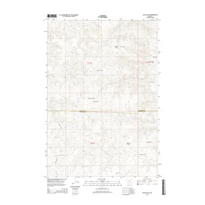
2014 Map of Lacey Gulch
USGS Topo · Published 2014About this map
The high plains of the Montana-Wyoming border region define this landscape where Rosebud and Big Horn counties meet. This survey captures a network of deeply eroded drainages and named gulches that have long shaped ranching and movement in the Big Horn Basin. Water sources are critical in this arid terrain, marked by the presence of 08S42E10AADC01 Spring and 08S42E16DDDC01 Spring along Harris Creek. Remote access is maintained through a handful of unpaved arteries, including Harris Creek Road and Quietus Road, which follow the natural contours of the land.
Find a feature on this map
21 named features on this map. Tap any name to fly to it.
Don’t see what you’re looking for? This feature index may not catch every label — zoom into the map to look around manually.
Map Details
Editions of this 2014 Lacey Gulch Map
This is the sole edition of this map. No revisions or reprints were ever made.
Other maps of this area

1954 · Hardin
USGS Topo · 1:250,000

1957 · Hardin
USGS Topo · 1:250,000

1958 · Hardin
USGS Topo · 1:250,000

1966 · Browns Mountain
USGS Topo · 1:24,000

1967 · Holmes Ranch
USGS Topo · 1:24,000

1967 · Birney
USGS Topo · 1:24,000

1967 · Lacey Gulch
USGS Topo · 1:24,000
1967 · Pine Butte School
USGS Topo · 1:24,000
1967 · Spring Gulch
USGS Topo · 1:24,000
1967 · Birney SW
USGS Topo · 1:24,000