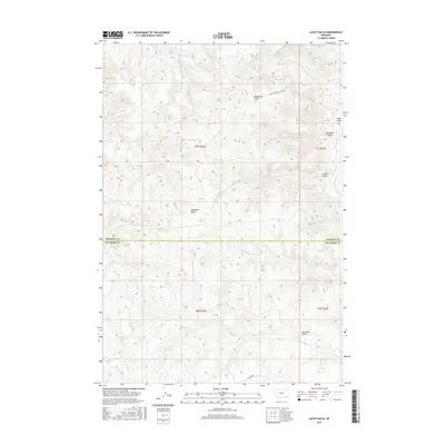
2017 Map of Lacey Gulch
USGS Topo · Published 2017About this map
Hanging Woman Cr meanders through this portion of the Montana prairie, defining a landscape of deep drainages and tributary draws. The terrain is marked by family-named and descriptive landmarks such as Van Meter Gulch, Haywood Gulch, and the starkly named Bad Land Gulch. This 2017 survey illustrates the remote character of the region near the Rosebud Co Big Horn Co boundary, where transport is limited to thoroughfares like Hanging Woman Creek Rd and Decker Rd. The map provides a detailed view of the complex hydrology of the high plains, showing how Wrench Cr, Harris Cr, and Wall Cr have carved the earth into a series of ridges and basins typical of this part of Big Horn and Rosebud counties.
Find a feature on this map
15 named features on this map. Tap any name to fly to it.
Don’t see what you’re looking for? This feature index may not catch every label — zoom into the map to look around manually.
Map Details
Editions of this 2017 Lacey Gulch Map
This is the sole edition of this map. No revisions or reprints were ever made.
Other maps of this area

1954 · Hardin
USGS Topo · 1:250,000

1957 · Hardin
USGS Topo · 1:250,000

1958 · Hardin
USGS Topo · 1:250,000

1966 · Browns Mountain
USGS Topo · 1:24,000

1967 · Holmes Ranch
USGS Topo · 1:24,000

1967 · Birney
USGS Topo · 1:24,000

1967 · Lacey Gulch
USGS Topo · 1:24,000
1967 · Pine Butte School
USGS Topo · 1:24,000
1967 · Spring Gulch
USGS Topo · 1:24,000
1967 · Birney SW
USGS Topo · 1:24,000