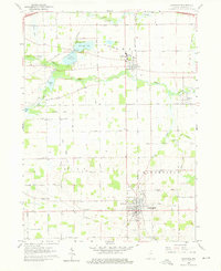
1960 Map of Lagrange
USGS Topo · Published 1961About this map
The Lagrange county seat serves as the focal point of this 1960 survey, showcasing a landscape defined by its systematic grid and the winding paths of the Pigeon River and Fawn River. The northern portion of the map is dominated by the educational and civic presence of the Howe Military Sch in Howe, while the historic Star Mill sits further north along the riverbanks. Local genealogy and land use are clearly visible through the numerous country cemeteries like Oaklawn Cem and Greenwood Cem, and the distribution of rural institutions such as Green Sch and Clay Sch.
Find a feature on this map
41 named features on this map. Tap any name to fly to it.
Don’t see what you’re looking for? This feature index may not catch every label — zoom into the map to look around manually.
Map Details
Editions of this 1960 Lagrange Map
Other maps of this area

1914 · Three Rivers
USGS Topo · 1:62,500

1916 · Three Rivers
USGS Topo · 1:62,500

1943 · Three Rivers
USGS Topo · 1:62,500

1947 · Mongo
USGS Topo · 1:24,000

1947 · Lagrange
USGS Topo · 1:24,000

1947 · Wolcottville
USGS Topo · 1:24,000

1947 · Oliver Lake
USGS Topo · 1:24,000

1953 · Fort Wayne
USGS Topo · 1:250,000

1956 · Fort Wayne
USGS Topo · 1:250,000

1959 · Wolcottville
USGS Topo · 1:24,000