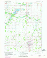
1960 Map of Lagrange
USGS Topo · Published 1982About this map
The town of Lagrange serves as the focal point of this Northern Indiana landscape, shown here as a bustling county seat featuring the County Hospital and a Sewage Disposal plant. To the north, the Howe Military Sch grounds are prominent near the community of Howe, while the waters of the Fawn River and Pigeon River wind through the countryside. This update includes purple revisions reflecting the mid-twentieth-century expansion of residential areas and the appearance of several Trailer Parks near the town center.
Find a feature on this map
42 named features on this map. Tap any name to fly to it.
Don’t see what you’re looking for? This feature index may not catch every label — zoom into the map to look around manually.
Map Details
Editions of this 1960 Lagrange Map
Other maps of this area

1914 · Three Rivers
USGS Topo · 1:62,500

1916 · Three Rivers
USGS Topo · 1:62,500

1943 · Three Rivers
USGS Topo · 1:62,500

1947 · Mongo
USGS Topo · 1:24,000

1947 · Lagrange
USGS Topo · 1:24,000

1947 · Wolcottville
USGS Topo · 1:24,000

1947 · Oliver Lake
USGS Topo · 1:24,000

1953 · Fort Wayne
USGS Topo · 1:250,000

1956 · Fort Wayne
USGS Topo · 1:250,000

1959 · Wolcottville
USGS Topo · 1:24,000