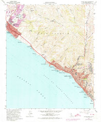
1965 Map of Laguna Beach
USGS Topo · Published 1974About this map
The San Joaquin Hills rise sharply from the coastline, where early development concentrated along the Pacific Coast Highway. This survey captures the mid-century expansion of communities like Laguna Beach and Corona del Mar before the extensive suburban infill of later decades. Significant civic and institutional landmarks are visible, including Pacific View Memorial Park, the St Catherine of Siena Sch, and the high-elevation neighborhood of Top of the World.
Find a feature on this map
63 named features on this map. Tap any name to fly to it.
Don’t see what you’re looking for? This feature index may not catch every label — zoom into the map to look around manually.
Map Details
Editions of this 1965 Laguna Beach Map
4 editions found
Other maps of this area

1896 · Santa Ana
USGS Topo · 1:62,500

1901 · Southern California Sheet No. 1
USGS Topo · 1:250,000

1901 · Santa Ana
USGS Topo · 1:62,500

1902 · Capistrano
USGS Topo · 1:125,000

1902 · Corona
USGS Topo · 1:125,000

1904 · Southern California Sheet No. 2
USGS Topo · 1:250,000

1904 · Southern California Sheet No. 1
USGS Topo · 1:250,000

1906 · Capistrano
USGS Topo · 1:125,000

1932 · Newport Beach
USGS Topo · 1:31,680

1932 · Tustin
USGS Topo · 1:31,680