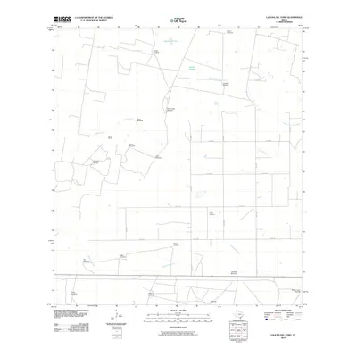
2010 Map of Laguna Del Toro
USGS Topo · Published 2010About this map
The arid landscape of Duval County is defined by a sparse network of ranching and industrial infrastructure in this 2010 topographic survey. Numerous water pumping sites, such as Rancho Vejo Windmill, Retema Windmill, and Numero Uno Windmill, are scattered across the terrain, illustrating the vital role of groundwater for livestock in this region. The map captures the working landscape of the Cibolo Ranch and the industrial footprint of the East Sejita Oil Field. Ephemeral water bodies like Laguna del Toro and Laguna Grande dot the northern reaches, while seasonal drainages including Cibolo Creek and Laborcitas Creek cut through the south. Cultural landmarks like Copita Cemetery provide a historical anchor for local genealogists studying the families that established these ranchlands.
Find a feature on this map
35 named features on this map. Tap any name to fly to it.
Don’t see what you’re looking for? This feature index may not catch every label — zoom into the map to look around manually.
Map Details
Editions of this 2010 Laguna Del Toro Map
This is the sole edition of this map. No revisions or reprints were ever made.
Other maps of this area

1921 · Falfurrias
USGS Topo · 1:125,000

1956 · Laredo
USGS Topo · 1:250,000

1963 · Premont West
USGS Topo · 1:24,000

1963 · Falfurrias
USGS Topo · 1:24,000
1963 · Seeligson Ranch
USGS Topo · 1:24,000

1968 · Palomas Ranch NW
USGS Topo · 1:24,000

1968 · Concepcion
USGS Topo · 1:24,000

1968 · Concepcion NW
USGS Topo · 1:24,000

1968 · Palomas Ranch
USGS Topo · 1:24,000
1969 · Laguna Del Toro
USGS Topo · 1:24,000