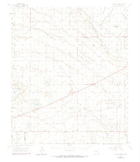
1963 Map of Laguna Gatuna
USGS Topo · Published 1974About this map
Querecho Plains and the prominent Mescalero (The Caprock) Ridge dominate this landscape on the border of Eddy and Lea Counties. The map reveals an intensive mid-century petroleum economy, with large operations such as the North Lynch Oil Field, South Corbin Oil Field, and Pearl Oil Field spread across the arid terrain. These industrial zones are interspersed with a network of cattle operations, including the Smith Ranch, Bingham Ranch, and Allred Ranch, illustrating the cohabitation of ranching and mineral extraction.
Find a feature on this map
25 named features on this map. Tap any name to fly to it.
Don’t see what you’re looking for? This feature index may not catch every label — zoom into the map to look around manually.
Map Details
Editions of this 1963 Laguna Gatuna Map
2 editions found

Other maps of this area

1939 · Nash Draw
USGS Topo · 1:62,500

1942 · Clayton Basin
USGS Topo · 1:62,500

1943 · Clayton Basin
USGS Topo · 1:62,500

1943 · Nash Draw
USGS Topo · 1:62,500

1954 · Hobbs
USGS Topo · 1:250,000

1958 · Hobbs
USGS Topo · 1:250,000

1962 · Lovington
USGS Topo · 1:62,500

1962 · Buckeye
USGS Topo · 1:62,500

1963 · Oil Center
USGS Topo · 1:62,500

1963 · Monument
USGS Topo · 1:62,500