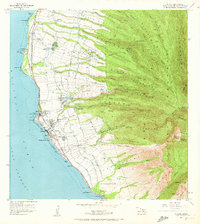
1956 Map of Lahaina
USGS Topo · Published 1972About this map
The agricultural and maritime character of West Maui is clearly delineated in this mid-century record of the Lahaina coastline. The landscape is defined by the sophisticated irrigation infrastructure required for sugar and pineapple production, featuring an intricate network of the Pipeline, Ditch, and Flume systems that draw water from mountain sources like Kahoma Stream to reservoirs including Wahikuli Reservoir. Coastal industrial hubs like Mala and the nearby Sugar Mill serve as the economic anchors for a series of worker settlements and neighborhoods, including Kelawea, Puunoa, and Lunaville.
Find a feature on this map
112 named features on this map. Tap any name to fly to it.
Don’t see what you’re looking for? This feature index may not catch every label — zoom into the map to look around manually.
Map Details
Editions of this 1956 Lahaina Map
2 editions found
Other maps of this area

1954 · Maui
USGS Topo · 1:250,000

1954 · Maalaea
USGS Topo · 1:24,000

1955 · Olowalu
USGS Topo · 1:24,000

1955 · Wailuku
USGS Topo · 1:24,000

1955 · Kahakuloa
USGS Topo · 1:24,000

1956 · Lahaina
USGS Topo · 1:24,000

1956 · Honolua
USGS Topo · 1:24,000

1966 · Maui
USGS Topo · 1:250,000

1974 · Maui
USGS Topo · 1:250,000

1977 · Wailuku
USGS Topo · 1:24,000