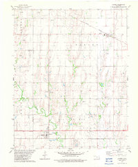
1982 Map of Lahoma
USGS Topo · Published 1983About this map
The Oklahoma prairie at the intersection of Major and Garfield counties is defined here by its agricultural grids and the extraction footprint of a significant Oil and Gas Field. Settlement centers on Lahoma, where the township grid meets the meandering path of Turkey Creek, and the town of Carrier to the northeast. The landscape is dotted with markers of local heritage, including rural burial grounds like Rose Hill Cem, Zion Cem, and Lahoma Cem.
Find a feature on this map
19 named features on this map. Tap any name to fly to it.
Don’t see what you’re looking for? This feature index may not catch every label — zoom into the map to look around manually.
Map Details
Editions of this 1982 Lahoma Map
This is the sole edition of this map. No revisions or reprints were ever made.
Other maps of this area

1955 · Enid West
USGS Topo · 1:24,000

1955 · Enid
USGS Topo · 1:250,000

1955 · Woodward
USGS Topo · 1:250,000

1956 · Enid
USGS Topo · 1:62,500

1956 · Ringwood
USGS Topo · 1:62,500

1958 · Enid
USGS Topo · 1:250,000

1958 · Woodward
USGS Topo · 1:250,000

1968 · Hillsdale
USGS Topo · 1:24,000

1969 · Goltry
USGS Topo · 1:24,000

1969 · Jet SE
USGS Topo · 1:24,000