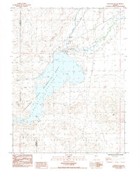
1985 Map of Lahontan Dam
USGS Topo · Published 1985About this map
Lahontan Reservoir State Recreation Area dominates this landscape where the desert floor meets essential water infrastructure in the mid-1980s. The map illustrates the convergence of the Carson River and the Truckee Canal, which feed the reservoir at the Lahontan Dam. This area serves as a critical junction for regional irrigation and transport, evidenced by the Southern Pacific railroad lines cutting through the northern and western sections of the quadrangle. Significant topographical features like the Dead Camel Mountains and the Virginia Range frame the basin, while localized landmarks such as The Narrows and Sixmile Beach detail the shoreline's character. The presence of numerous prospects and borrow pits reflects the ongoing extractive history of the region, while a lone Historical Marker northwest of the water suggests a recorded legacy prior to the reservoir's expansion.
Find a feature on this map
38 named features on this map. Tap any name to fly to it.
Don’t see what you’re looking for? This feature index may not catch every label — zoom into the map to look around manually.
Map Details
Editions of this 1985 Lahontan Dam Map
2 editions found
Other maps of this area

1890 · Wadsworth
USGS Topo · 1:125,000

1891 · Wabuska
USGS Topo · 1:125,000

1892 · Wadsworth
USGS Topo · 1:125,000

1894 · Wadsworth
USGS Topo · 1:125,000

1894 · Wabuska
USGS Topo · 1:125,000

1908 · Carson Sink
USGS Topo · 1:250,000

1910 · Carson Sink
USGS Topo · 1:250,000

1951 · Soda Lake
USGS Topo · 1:62,500

1951 · Fallon
USGS Topo · 1:62,500

1957 · Two Tips
USGS Topo · 1:62,500