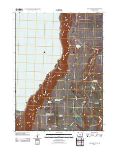
2011 Map of Lake Abert South
USGS Topo · Published 2011About this map
Abert Rim dominates the eastern landscape of this high desert region in Lake County, forming a sheer escarpment that overlooks the expansive alkaline waters of Lake Abert. This 2011 survey reveals a territory defined by its water management and sparse, critical resources, where seasonal drainages like Rabbit Creek and Snyder Creek feed into small, named catchments. The naming convention of remote sites such as Fish Creek Waterhole Number Forty and Fish Creek Waterhole Number Forty-seven suggests a landscape meticulously cataloged for ranching or land management. Smaller water bodies like Mule Lake, Paddys Lake, and Spawn Reservoir are scattered across the basin, while Webb Springs provides a rare point of natural outflow. This map provides a detailed view of the rugged topography east of the lake, tracing the intricate network of draws and seasonal pools.
Find a feature on this map
19 named features on this map. Tap any name to fly to it.
Don’t see what you’re looking for? This feature index may not catch every label — zoom into the map to look around manually.
Map Details
Editions of this 2011 Lake Abert South Map
This is the sole edition of this map. No revisions or reprints were ever made.
Other maps of this area

1955 · Klamath Falls
USGS Topo · 1:250,000

1958 · Klamath Falls
USGS Topo · 1:250,000

1964 · Valley Falls
USGS Topo · 1:24,000

1966 · Coglan Buttes NE
USGS Topo · 1:24,000

1966 · Coglan Buttes SE
USGS Topo · 1:24,000
1968 · Drake Peak NE
USGS Topo · 1:24,000

1968 · Lake Abert North
USGS Topo · 1:24,000

1968 · Lake Abert South
USGS Topo · 1:24,000
1968 · Little Honey Creek
USGS Topo · 1:24,000
1968 · Cooper Draw
USGS Topo · 1:24,000