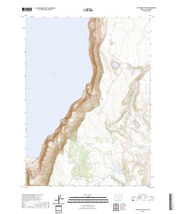
2024 Map of Lake Abert South
USGS Topo · Published 2024About this map
The towering Abert Rim dominates this section of south-central Oregon, dropping sharply toward the expansive, saline waters of Lake Abert to the west. This landscape illustrates the dramatic Great Basin geology, where a massive fault scarp creates a vertical wall of basalt that separates the high plateau from the alkali lake below. The eastern portion of the map reveals a series of critical high-desert water sources, including Sheep Creek Spring and Webb Springs, which feed into complex drainages like Mule Draw. Local ranchers and land managers have modified this environment with features such as Spawn Reservoir and the Lower Basin Draw Reservoir, alongside various named stock tanks like Juniper Waterhole. These features highlight the ongoing efforts to manage water for livestock and wildlife across this arid, high-elevation terrain.
Find a feature on this map
21 named features on this map. Tap any name to fly to it.
Don’t see what you’re looking for? This feature index may not catch every label — zoom into the map to look around manually.
Map Details
Editions of this 2024 Lake Abert South Map
This is the sole edition of this map. No revisions or reprints were ever made.
Other maps of this area

1955 · Klamath Falls
USGS Topo · 1:250,000

1958 · Klamath Falls
USGS Topo · 1:250,000

1964 · Valley Falls
USGS Topo · 1:24,000

1966 · Coglan Buttes NE
USGS Topo · 1:24,000

1966 · Coglan Buttes SE
USGS Topo · 1:24,000
1968 · Drake Peak NE
USGS Topo · 1:24,000

1968 · Lake Abert North
USGS Topo · 1:24,000

1968 · Lake Abert South
USGS Topo · 1:24,000
1968 · Little Honey Creek
USGS Topo · 1:24,000
1968 · Cooper Draw
USGS Topo · 1:24,000