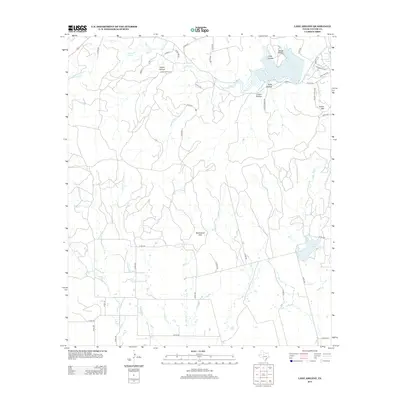
2012 Map of Lake Abilene
USGS Topo · Published 2012About this map
Lake Abilene and its surrounding watershed define this Taylor County landscape, which transitions from water-management infrastructure to rugged topographic landmarks. The presence of Abilene State Park near the reservoir highlights the region's mid-century recreational development, while local peaks such as Steamboat Mtn and Indian Mtn provide significant vertical relief against the creek drainages. A network of ranch roads, including Rock Ranch Rd and Heinze Ranch Rd, suggests a long-standing pastoral economy and property division patterns. Several distinct hollows like Scott Hollow and Brock Hollow branch off from the main lake, while further south, Lake Bulger serves as another focal point for local water resources and geography. The map also traces the winding courses of Elm Cr and Bulger Cr, illustrating the drainage systems that feed these reservoirs.
Find a feature on this map
52 named features on this map. Tap any name to fly to it.
Don’t see what you’re looking for? This feature index may not catch every label — zoom into the map to look around manually.
Map Details
Editions of this 2012 Lake Abilene Map
This is the sole edition of this map. No revisions or reprints were ever made.
Other maps of this area

1890 · Abilene
USGS Topo · 1:125,000

1892 · Abilene
USGS Topo · 1:125,000

1893 · Sweetwater
USGS Topo · 1:125,000

1954 · Big Spring
USGS Topo · 1:250,000

1954 · Abilene
USGS Topo · 1:250,000

1957 · Merkel
USGS Topo · 1:62,500

1957 · Buffalo Gap
USGS Topo · 1:62,500

1958 · Big Spring
USGS Topo · 1:250,000

1958 · Abilene
USGS Topo · 1:250,000
1967 · Shep
USGS Topo · 1:24,000