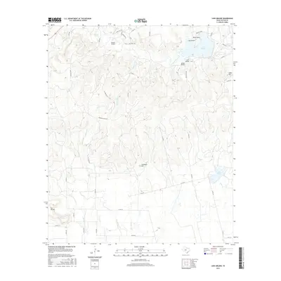
2016 Map of Lake Abilene
USGS Topo · Published 2016About this map
Lake Abilene anchors the northern landscape of this Taylor County terrain, serving as a primary water feature fed by Elm Cr. The surrounding topography is defined by a series of significant elevations and deeply cut hollows, including Steamboat Mtn and Indian Mtn to the east. The drainage network is complex, with Bulger Cr flowing into Lake Bulger in the southeast, while Pleasant Run and Elmont Cr traverse the central and western reaches. This 2016 survey illustrates a rural landscape where large-scale ranching and land management are evident through named corridors like Heinze Ranch Rd and Arrowhead Ranch Rd. Numerous named hollows such as Scott Hollow and Jordan Hollow suggest a historical pattern of local land use tied to the specific draws and springs, like Buckett Springs, which are vital in this semi-arid environment.
Find a feature on this map
51 named features on this map. Tap any name to fly to it.
Don’t see what you’re looking for? This feature index may not catch every label — zoom into the map to look around manually.
Map Details
Editions of this 2016 Lake Abilene Map
This is the sole edition of this map. No revisions or reprints were ever made.
Other maps of this area

1890 · Abilene
USGS Topo · 1:125,000

1892 · Abilene
USGS Topo · 1:125,000

1893 · Sweetwater
USGS Topo · 1:125,000

1954 · Big Spring
USGS Topo · 1:250,000

1954 · Abilene
USGS Topo · 1:250,000

1957 · Merkel
USGS Topo · 1:62,500

1957 · Buffalo Gap
USGS Topo · 1:62,500

1958 · Big Spring
USGS Topo · 1:250,000

1958 · Abilene
USGS Topo · 1:250,000
1967 · Shep
USGS Topo · 1:24,000