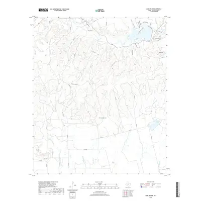
2019 Map of Lake Abilene
USGS Topo · Published 2019About this map
Lake Abilene anchors the northeastern landscape of this Taylor County region, serving as a significant water feature amidst a complex network of creeks and deep drainages. The area is defined by its dramatic relief, where prominent landmarks like Steamboat Mtn and Flat Top Mtn rise above the surrounding terrain. Small water sources such as Buckett Springs and seasonal drainages like Coon Hollow and Jordan Hollow indicate the natural hydrology that has shaped land use here for generations.
Find a feature on this map
55 named features on this map. Tap any name to fly to it.
Don’t see what you’re looking for? This feature index may not catch every label — zoom into the map to look around manually.
Map Details
Editions of this 2019 Lake Abilene Map
This is the sole edition of this map. No revisions or reprints were ever made.
Other maps of this area

1890 · Abilene
USGS Topo · 1:125,000

1892 · Abilene
USGS Topo · 1:125,000

1893 · Sweetwater
USGS Topo · 1:125,000

1954 · Big Spring
USGS Topo · 1:250,000

1954 · Abilene
USGS Topo · 1:250,000

1957 · Merkel
USGS Topo · 1:62,500

1957 · Buffalo Gap
USGS Topo · 1:62,500

1958 · Big Spring
USGS Topo · 1:250,000

1958 · Abilene
USGS Topo · 1:250,000
1967 · Shep
USGS Topo · 1:24,000