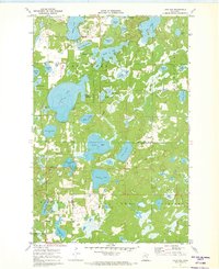
1971 Map of Lake Ada
USGS Topo · Published 1973About this map
Glacial lakes and wetlands dominate this portion of the northern woods where Ponto Lake and the massive Lake Ada provide a central focus for the region's geography. The map captures the small community of Pontoria and the lakeside development at Chickamaw Beach as they appeared in the early 1970s. Historical local markers like the Ponto Lake Cem and the Townhall near Lizotte Lake offer specific points of interest for genealogists tracing family roots in Barclay and Gould townships. The landscape is interconnected by a complex drainage system including Blind Creek and Lizzie Creek, alongside more isolated features like Deadman Lake and Jail Lake. Evidence of local industry is sparse but visible through a scattered Sandpit and Gravel Pit, while a Winter Trail in the southeast suggests the seasonal nature of transport and recreation in the Cass County backcountry.
Find a feature on this map
41 named features on this map. Tap any name to fly to it.
Don’t see what you’re looking for? This feature index may not catch every label — zoom into the map to look around manually.
Map Details
Editions of this 1971 Lake Ada Map
2 editions found
Other maps of this area

1953 · Brainerd
USGS Topo · 1:250,000

1957 · Brainerd
USGS Topo · 1:250,000

1958 · Brainerd
USGS Topo · 1:250,000

1959 · Lower Whitefish Lake
USGS Topo · 1:24,000

1959 · Pine River
USGS Topo · 1:24,000

1959 · Jenkins
USGS Topo · 1:24,000

1965 · Brainerd
USGS Topo · 1:250,000
1970 · Mildred
USGS Topo · 1:24,000

1970 · Webb Lake
USGS Topo · 1:24,000

1970 · Woman Lake
USGS Topo · 1:24,000