
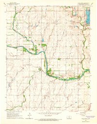
1965 Map of Lake Afton
USGS Topo · Published 1983About this map
The South Fork Ninnescah River carves a prominent path across this rural Kansas landscape, where agricultural fields are divided by a network of farm roads and fences. In the northeastern corner, the waters of Lake Afton and Clear Lake serve as a focal point for the surrounding Afton and Morton townships. The map documents the specific social infrastructure of the mid-1960s, including the Lake Afton Boys Ranch and Camp Hyde, alongside essential local sites like Peotone Cem in the southern reaches of the quadrangle. A system of creeks, such as Mud Creek, Jocelyn Creek, and Spring Creek, feeds into the main river valley, illustrating the drainage patterns of the Sedgwick County countryside. The inclusion of a major Pipeline cutting through several sections reflects the expanding industrial utility footprint in this traditional farming region.
Find a feature on this map
24 named features on this map. Tap any name to fly to it.
Don’t see what you’re looking for? This feature index may not catch every label — zoom into the map to look around manually.
Map Details
Editions of this 1965 Lake Afton Map
2 editions found
Other maps of this area

1889 · Cheney
USGS Topo · 1:125,000

1889 · Caldwell
USGS Topo · 1:125,000

1891 · Cheney
USGS Topo · 1:125,000

1893 · Caldwell
USGS Topo · 1:125,000

1897 · Caldwell
USGS Topo · 1:125,000

1901 · Cheney
USGS Topo · 1:125,000

1955 · Wichita
USGS Topo · 1:250,000

1958 · Wichita
USGS Topo · 1:250,000

1964 · Cheney
USGS Topo · 1:24,000

1965 · Garden Plain
USGS Topo · 1:24,000