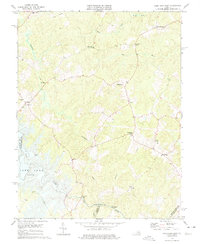
1973 Map of Lake Anna East
USGS Topo · Published 1975About this map
Lake Anna and the North Anna River dominate this Central Virginia landscape during a period of transition in the early 1970s. The map illustrates the rural character of Spotsylvania County, where established crossroads like Penneys Crossroad and Chewnings Corner served as local hubs. The network of small community centers is anchored by several country churches, including Wallers Ch and New Hope Ch, alongside historical school sites such as Livingston Sch. Transportation across the river and its tributaries is marked by named crossings like Smiths Mill Bridge and Davenport Bridge, indicating the long-standing importance of water power and passage in the local economy. Settlement patterns follow the winding routes through small villages such as Lewiston and Partlow, while the interior remains defined by the drainages of Northeast Creek and the Mat River.
Find a feature on this map
32 named features on this map. Tap any name to fly to it.
Don’t see what you’re looking for? This feature index may not catch every label — zoom into the map to look around manually.
Map Details
Editions of this 1973 Lake Anna East Map
4 editions found
Other maps of this area

1887 · Spottsylvania
USGS Topo · 1:125,000

1890 · Goochland
USGS Topo · 1:125,000

1892 · Spottsylvania
USGS Topo · 1:125,000

1892 · Goochland
USGS Topo · 1:125,000

1942 · Ladysmith
USGS Topo · 1:31,680

1942 · Partlow
USGS Topo · 1:31,680

1942 · Belmont
USGS Topo · 1:31,680

1942 · Contrary Creek
USGS Topo · 1:31,680

1942 · Spotsylania
USGS Topo · 1:31,680

1942 · Brokenburg
USGS Topo · 1:31,680