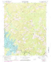
1973 Map of Lake Anna East
USGS Topo · Published 1984About this map
The North Anna River and the expanding waters of Lake Anna define this portion of the Virginia Piedmont during a period of transition in the 1970s. The map captures a landscape of crossroads communities and rural institutions, including the Livingston Sch and numerous country churches such as St Johns Ch and Wallers Ch. Small commercial and social hubs are clustered at junctions like Penneys Crossroad, Gatewood, and Duerson Store, reflecting a traditional settlement pattern centered on local trade and worship.
Find a feature on this map
26 named features on this map. Tap any name to fly to it.
Don’t see what you’re looking for? This feature index may not catch every label — zoom into the map to look around manually.
Map Details
Editions of this 1973 Lake Anna East Map
4 editions found
Other maps of this area

1887 · Spottsylvania
USGS Topo · 1:125,000

1890 · Goochland
USGS Topo · 1:125,000

1892 · Spottsylvania
USGS Topo · 1:125,000

1892 · Goochland
USGS Topo · 1:125,000

1942 · Ladysmith
USGS Topo · 1:31,680

1942 · Partlow
USGS Topo · 1:31,680

1942 · Belmont
USGS Topo · 1:31,680

1942 · Contrary Creek
USGS Topo · 1:31,680

1942 · Spotsylania
USGS Topo · 1:31,680

1942 · Brokenburg
USGS Topo · 1:31,680