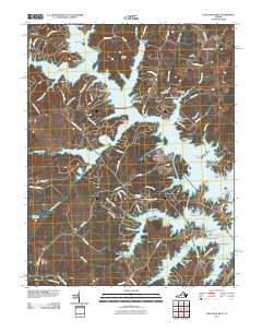
2010 Map of Lake Anna West
USGS Topo · Published 2010About this map
Lake Anna dominates this landscape, its sprawling fingers and numerous inlets defining the geography of eastern Spotsylvania County. The shoreline is punctuated by a dense network of residential landings and recreation points, including Rocky Branch Marina and Sturgeon Creek Marina near Glenora. This modern topographical survey shows a region deeply transformed by water management, where numerous former stream valleys like Mitchell Creek and Bohemian Bay have become major arms of the lake. Historical echoes remain in the surrounding countryside at Centreville and Plum Tree, where older land patterns persist away from the immediate waterfront. Genealogists will find several notable burial sites documented, such as Goodhope Cemetery, Bethel Cemetery, and Laurel Hill Cemetery, providing valuable anchors for local family history research in this evolving Virginia landscape.
Find a feature on this map
98 named features on this map. Tap any name to fly to it.
Don’t see what you’re looking for? This feature index may not catch every label — zoom into the map to look around manually.
Map Details
Editions of this 2010 Lake Anna West Map
This is the sole edition of this map. No revisions or reprints were ever made.
Other maps of this area

1887 · Spottsylvania
USGS Topo · 1:125,000

1890 · Goochland
USGS Topo · 1:125,000

1892 · Spottsylvania
USGS Topo · 1:125,000

1892 · Goochland
USGS Topo · 1:125,000

1942 · Mineral
USGS Topo · 1:31,680

1942 · Lahore
USGS Topo · 1:31,680

1942 · Partlow
USGS Topo · 1:31,680

1942 · Belmont
USGS Topo · 1:31,680

1942 · Contrary Creek
USGS Topo · 1:31,680

1942 · Brokenburg
USGS Topo · 1:31,680