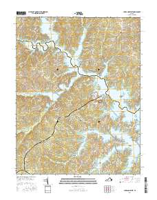
2016 Map of Lake Anna West
USGS Topo · Published 2016About this map
Lake Anna dominates this 2016 study, where the borders of Spotsylvania Co and Louisa Co meet across the water. The landscape is defined by an intricate network of coves and points, including Bohemian Bay, Shaffers Cove, and family-named landmarks like Mitchells Point and Duerson Point. Small settlements such as Glenora and Centreville are situated inland, while Holladay marks the northwestern corner. The area’s historical infrastructure is visible through numerous cemeteries like Goodhope Cem and Laurel Hill Cem, alongside several millponds such as Lacy Millpond and Whitlock Millpond. Numerous islands, including Jetts Island and Thurman Island, dot the reservoir, illustrating the contemporary shoreline development and residential expansion along Kentucky Springs Rd.
Find a feature on this map
181 named features on this map. Tap any name to fly to it.
Don’t see what you’re looking for? This feature index may not catch every label — zoom into the map to look around manually.
Map Details
Editions of this 2016 Lake Anna West Map
This is the sole edition of this map. No revisions or reprints were ever made.
Other maps of this area

1887 · Spottsylvania
USGS Topo · 1:125,000

1890 · Goochland
USGS Topo · 1:125,000

1892 · Spottsylvania
USGS Topo · 1:125,000

1892 · Goochland
USGS Topo · 1:125,000

1942 · Mineral
USGS Topo · 1:31,680

1942 · Lahore
USGS Topo · 1:31,680

1942 · Partlow
USGS Topo · 1:31,680

1942 · Belmont
USGS Topo · 1:31,680

1942 · Contrary Creek
USGS Topo · 1:31,680

1942 · Brokenburg
USGS Topo · 1:31,680