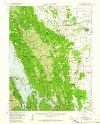
1959 Map of Lake Berryessa
USGS Topo · Published 1961About this map
Lake Berryessa dominates the western portion of this 1959 survey, showing the recently formed reservoir following the completion of the Monticello Dam. The landscape reveals a sharp divide between the steep, ridge-cut terrain of the Vaca Mountains and the irrigated agricultural lands of Hungry Hollow to the east. Along the eastern edge, the Southern Pacific railroad line serves the town of Esparto, while various sloughs like Chickahominy Slough and Union School Slough drain the valley floor. This period marks the early rise of water-based recreation in the region, evidenced by the development of the Spanish Flat Resort, Steel Canyon Resort, and the Lake Berryessa Park Hdqrs. Local heritage is preserved in family-named landmarks like Gunn Ranch and the Scott Ranch, alongside institutional markers such as the Union School and Capay Cemetery.
Find a feature on this map
87 named features on this map. Tap any name to fly to it.
Don’t see what you’re looking for? This feature index may not catch every label — zoom into the map to look around manually.
Map Details
Editions of this 1959 Lake Berryessa Map
2 editions found
Other maps of this area

1902 · Napa
USGS Topo · 1:125,000

1905 · Esparto
USGS Topo · 1:24,000

1907 · Dunnigan
USGS Topo · 1:62,500

1907 · Woodland
USGS Topo · 1:62,500

1908 · Vacaville
USGS Topo · 1:62,500

1916 · Jacobs Corner
USGS Topo · 1:31,680

1916 · Zamora
USGS Topo · 1:31,680

1916 · Winters
USGS Topo · 1:31,680

1916 · Esparto
USGS Topo · 1:31,680

1917 · Wolfskill
USGS Topo · 1:31,680