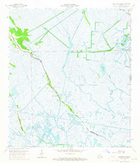
1964 Map of Lake Bully Camp
USGS Topo · Published 1965About this map
Bayou Pointe au Chien serves as the primary corridor for human settlement in this mid-1960s survey, marking the boundary between Lafourche Parish and Terrebonne Parish. Along this winding waterway, a thin string of community life is documented through the Lower Pointe au Chien Sch, Live Oak Ch, and St Peters Ch. These structures represent the high-ground footprint of South Louisiana's coastal culture before significant coastal land loss altered the landscape.
Find a feature on this map
20 named features on this map. Tap any name to fly to it.
Don’t see what you’re looking for? This feature index may not catch every label — zoom into the map to look around manually.
Map Details
Editions of this 1964 Lake Bully Camp Map
4 editions found
Other maps of this area

1892 · Cut-Off
USGS Topo · 1:62,500

1892 · Houma
USGS Topo · 1:62,500

1894 · Lake Felicity
USGS Topo · 1:62,500

1894 · Dulac
USGS Topo · 1:62,500

1932 · Houma SE
USGS Topo · 1:31,680

1935 · Bourbeux
USGS Topo · 1:31,680

1935 · Viguerie Canal
USGS Topo · 1:31,680

1935 · Montegut
USGS Topo · 1:31,680

1935 · Bay Courant
USGS Topo · 1:31,680

1935 · Golden Meadow
USGS Topo · 1:31,680