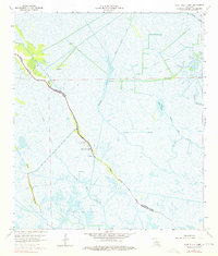
1964 Map of Lake Bully Camp
USGS Topo · Published 1976About this map
Bayou Pointe au Chien serves as the primary artery of settlement and movement through this section of south Louisiana in the mid-1960s. The landscape is a complex network of natural waterways and industrial alterations, characterized by the extensive Bully Camp Oil and Gas Field and the southern Bayou Jean Lacroix Oil and Gas Field. Numerous drill holes and canals like the Cutoff Canal and St Louis Canal reveal the footprint of the petroleum industry across the marsh. Along the central bayou ridge, a thin ribbon of community life is visible, anchored by Live Oak Ch, St Peters Ch, and the Lower Pointe au Chien Sch. This era captures the delicate balance between the area's traditional coastal ecology and the expanding energy infrastructure centered around Lake Bully Camp and the winding Bayou Salle.
Find a feature on this map
22 named features on this map. Tap any name to fly to it.
Don’t see what you’re looking for? This feature index may not catch every label — zoom into the map to look around manually.
Map Details
Editions of this 1964 Lake Bully Camp Map
4 editions found
Other maps of this area

1892 · Cut-Off
USGS Topo · 1:62,500

1892 · Houma
USGS Topo · 1:62,500

1894 · Lake Felicity
USGS Topo · 1:62,500

1894 · Dulac
USGS Topo · 1:62,500

1932 · Houma SE
USGS Topo · 1:31,680

1935 · Bourbeux
USGS Topo · 1:31,680

1935 · Viguerie Canal
USGS Topo · 1:31,680

1935 · Montegut
USGS Topo · 1:31,680

1935 · Bay Courant
USGS Topo · 1:31,680

1935 · Golden Meadow
USGS Topo · 1:31,680