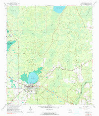
1966 Map of Lake Butler
USGS Topo · Published 1989About this map
The town of Lake Butler serves as the focal point for this mid-1960s survey, situated along the northern shore of the lake that shares its name. The landscape is defined by an extensive network of wetlands and drainage basins, including the Swift Creek Swamp, Black Swamp, and the timber-rich expanse of Piney Bay. This era shows a community deeply tied to both the land and its transport infrastructure, with the crossing of the Atlantic Coast Line and Southern railroads facilitating local commerce. Outside the main settlement, rural life is marked by several historical faith and burial sites such as Johnstown Ch, Varnes Cem, and Mt Zion Ch. The southeastern corner transitions into the New River basin, where the Union Co Bradford Co line follows the natural curvature of the waterway near McKinney Branch.
Find a feature on this map
29 named features on this map. Tap any name to fly to it.
Don’t see what you’re looking for? This feature index may not catch every label — zoom into the map to look around manually.
Map Details
Editions of this 1966 Lake Butler Map
3 editions found

Other maps of this area

1918 · Lawtey
USGS Topo · 1:62,500

1941 · Starke
USGS Topo · 1:62,500

1948 · Starke
USGS Topo · 1:50,000

1949 · Sampson
USGS Topo · 1:24,000

1949 · Starke
USGS Topo · 1:62,500

1954 · Gainesville
USGS Topo · 1:250,000

1954 · Valdosta
USGS Topo · 1:250,000

1958 · Valdosta
USGS Topo · 1:250,000

1958 · Gainesville
USGS Topo · 1:250,000

1959 · Valdosta
USGS Topo · 1:250,000