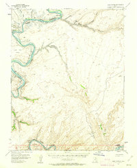
1953 Map of Lake Canyon
USGS Topo · Published 1962About this map
Cliff Dwellings and a single Cliff Dwelling tucked into the sandstone alcoves of Lake Canyon provide a glimpse into the archaeological depth of this region during the early 1950s. The map illustrates a transitional landscape where the Colorado River and San Juan River are identified by both their historical names and the impoundment that would soon alter the riverine environment. Along the river banks, a series of named sandbars including Moki Bar, Amphitheater Bar, New Year Bar, and Shock Bar reflect the pre-inundation geography of Glen Canyon. The southern portion of the survey is dominated by the Navajo Indian Reservation, featuring landmarks such as the Great Bend and Nokai Dome. Early industrial footprints are marked by a Landing Field, a Mine, and isolated oil wells, indicating the push for resource exploration in this corner of San Juan County.
Find a feature on this map
29 named features on this map. Tap any name to fly to it.
Don’t see what you’re looking for? This feature index may not catch every label — zoom into the map to look around manually.
Map Details
Editions of this 1953 Lake Canyon Map
3 editions found
Other maps of this area

1886 · Henry Mountains
USGS Topo · 1:250,000

1892 · Henry Mountains
USGS Topo · 1:250,000

1952 · Mancos Mesa
USGS Topo · 1:62,500

1952 · Clay Hills 3 NW
USGS Topo · 1:24,000

1952 · Navajo Mountain 4 NE
USGS Topo · 1:24,000

1952 · Oljeto
USGS Topo · 1:62,500

1953 · Navajo Mountain 4 NW
USGS Topo · 1:24,000

1953 · The Rincon
USGS Topo · 1:62,500

1953 · Lake Canyon
USGS Topo · 1:62,500

1953 · Mt. Ellsworth
USGS Topo · 1:62,500