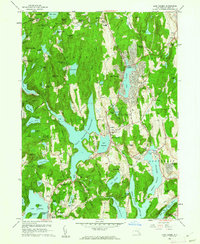
1960 Map of Lake Carmel
USGS Topo · Published 1962About this map
Farmers Mills and the surrounding highlands of Putnam County define this landscape, where mid-century residential growth meets the critical water infrastructure of the New York City reservoir system. The map captures the significant footprint of the West Branch Reservoir and Middle Branch Reservoir, which dominate the central and eastern terrain. Local life centers on established settlements like Lake Carmel and Mahopac, while educational and religious anchors such as St James the Apostle Sch and the Hermitage of Our Lady of Kursk provide specific points of interest for genealogists tracing 20th-century community development.
Find a feature on this map
86 named features on this map. Tap any name to fly to it.
Don’t see what you’re looking for? This feature index may not catch every label — zoom into the map to look around manually.
Map Details
Editions of this 1960 Lake Carmel Map
4 editions found
Other maps of this area

1892 · West Point
USGS Topo · 1:62,500

1892 · Carmel
USGS Topo · 1:62,500

1893 · Carmel
USGS Topo · 1:62,500

1893 · Clove
USGS Topo · 1:62,500

1893 · Poughkeepsie
USGS Topo · 1:62,500

1894 · West Point
USGS Topo · 1:62,500

1894 · Clove
USGS Topo · 1:62,500

1894 · Carmel
USGS Topo · 1:62,500

1894 · Poughkeepsie
USGS Topo · 1:62,500

1898 · Clove
USGS Topo · 1:62,500