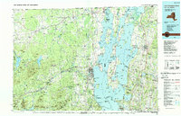
1986 Map of Lake Champlain North
USGS Topo · Published 1989About this map
Lake Champlain defines the heart of this landscape, its waters separating the Adirondack Mountains of New York from the islands and plains of Vermont during the mid-1980s. The region's strategic importance is evident at the Plattsburgh Air Force Base and the State Prison, while the border-crossing economy is reflected in the path of the Canadian National RR and Delaware & Hudson RR. Settlements like Rouses Point and Champlain stand as gatekeepers to Canada, linked to Vermont via the islands of North Hero Island and Grand Isle. To the west, the terrain rises sharply toward Lyon Mountain, while the east is dominated by the sprawling wetlands of the Missisquoi National Wildlife Refuge and the agricultural reaches of Highgate Center and Fairfax. This map documents a period of established military presence and stable rural townships before significant late-century shifts in regional infrastructure.
Find a feature on this map
159 named features on this map. Tap any name to fly to it.
Don’t see what you’re looking for? This feature index may not catch every label — zoom into the map to look around manually.
Map Details
Editions of this 1986 Lake Champlain North Map
2 editions found

Other maps of this area

1894 · Plattsburg
USGS Topo · 1:62,500

1895 · Mooers
USGS Topo · 1:62,500

1895 · Rouse Point
USGS Topo · 1:62,500

1895 · Willsboro
USGS Topo · 1:62,500

1895 · Ausable
USGS Topo · 1:62,500

1896 · Lake Placid
USGS Topo · 1:62,500

1898 · Lake Placid
USGS Topo · 1:62,500
1899 · Mooers
USGS Topo · 1:62,500

1902 · Saranac
USGS Topo · 1:62,500

1903 · Ausable
USGS Topo · 1:62,500