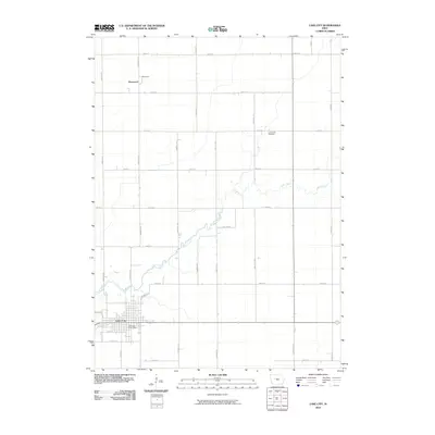
2010 Map of Lake City
USGS Topo · Published 2010About this map
Lake City anchors the southern portion of this Iowa landscape, where the local street grid is centered around the Lake City Post Office and intersections like W 6th St and S West St. The surrounding terrain is defined by a strictly organized township and range survey system, with a dense network of gravel and paved roads such as Jennings Ave and 350th St carving the prairie into uniform agricultural plots. Cutting diagonally through this rigid grid is Lake Creek, a wandering waterway that provides the only natural irregularity in the region. Near the creek's northern bends, the Lake Creek Cemetery serves as a quiet landmark for local genealogical research. To the north, the small settlement of Sherwood sits at a crossroads, representing the small rural hubs that supported the area's farming economy at the start of the twenty-first century.
Find a feature on this map
27 named features on this map. Tap any name to fly to it.
Don’t see what you’re looking for? This feature index may not catch every label — zoom into the map to look around manually.
Map Details
Editions of this 2010 Lake City Map
This is the sole edition of this map. No revisions or reprints were ever made.
Other maps of this area

1954 · Fort Dodge
USGS Topo · 1:250,000

1957 · Fort Dodge
USGS Topo · 1:250,000

1958 · Fort Dodge
USGS Topo · 1:250,000

1980 · Lytton
USGS Topo · 1:24,000

1980 · Rockwell City
USGS Topo · 1:24,000

1980 · Carroll NE
USGS Topo · 1:24,000

1980 · Yetter
USGS Topo · 1:24,000

1980 · Wightman
USGS Topo · 1:24,000
1980 · Lanesboro
USGS Topo · 1:24,000
1980 · Richard
USGS Topo · 1:24,000